EXACT AND NATURAL SCIENCES
There are no doubts: it is a cloud
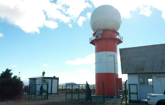
This high-tech radar will enhance the prediction of weather events that affect Argentina.
The first operational dual-polarization radar with Doppler technology made in Argentina was installed in the province of Córdoba. Together with other ten similar devices, this radar will be part of the Sistema Nacional de Radares Meteorológicos (SINARAME) [National Weather Radars System], which will identify and monitor hydrometeolorogical hazards and improve weather alerts to reduce the consequences of weather events with great social impact.
It is vital for men to predict, somehow, the effects of a severe storm from ancient times. Throughout history men analyzed different data in order to understand and warn the population about the scourges of nature. The first people to be interested in weather were the Chinese because they needed torrential rains for rice crops. After them, Phoenicians and the Greek sought to predict the frequency and speed of winds, as they frequently sailed the Mediterranean Sea.
In 400 BC Aristotle wrote a treaty called Meteorologica, which was focused on atmospheric events. Long after that, during the First World War, scientists developed new mathematical solutions and technological devices that led to new predictions based on the general observation of the atmosphere. In fact, the advances in thermodynamics and aerodynamics provided meteorology with a more solid theoretical basis.
Currently, the Radar Meteorológico Argentino (RMA) [Argentine Meteorological Radar] is located in the Universidad Nacional de Córdoba [National University of Córdoba] and has a 33-meters high tower, topped by a ball with a diemter of 6-meters. This device was produced by the company INVAP S.E. through a contract with the Ministerio de Planificación Federal, Inversión Pública y Servicios [Federal Ministry of Planning, Public Investment and Services]. This is the first step of a national plan presented in November 2011 in order to develop a network of national meteorological radars with a centralized real-time information system at the National Weather Service of Argentina.
As regards that, Paola Salio, CONICET associate researcher at the Research Centre for the Sea and the Atmosphere (CIMA, CONICET-UBA) and professor at the Department of Atmospheric and Oceanic Sciences of the Faculty of Exact and Natural Sciences of the UBA, explains that this radar is used to locate rains, calculate their trajectory and estimate the type of hydrometeors that are part of the system: rain, snow or even hail. “This technology is in line with the best world standards”, she adds.
¿How does this radar work? As it can obtain three-dimensional data and thus not only be based on the observation of the phenomenon, it allows determining the structures of storms, their potential trajectory and damage, apart from facilitating the measuring of the velocity of the precipitation particles, the shape or the geometry of the phenomenon detected. Thus, it is possible to determine if what is observed is a water drop, a crystal, a lobster or just dust.
“These are dual-polarization radars, which means that it is possible to obtain a meteorological echo-signal in the two electromagnetic scales, a vertical and an horizontal one, hence it also helps to determine the characteristics of the cloud”, Salio describes. Besides, as the system includes several algorithms, the scientists are in charge of interpreting the information once the radar transmits the signal – which is detected by a receiver – and generate appropriate algorithms for weather forecast offices according to the needs.
After the installation of all the radars and the headquarters with the software developed specially for this data processing, the information obtained by this equipment will have several uses: description of the weather, nowcasting; monitoring of environmental hazards (hail, torrential rains, severe storms, tornados, etcetera); navigational and air navigation safety; studies on atmospheric physics and the input of basic information for scientific and technological research.
In Argentina there are several places that do not have this technology. With the information of these new devices and the implementation of numerical modelling, it will be possible to provide a forecast that offers the largest margin of possible time action, on a better defined area, and with an enhanced characterization of severe weather events. “The idea is to warn the population about heavy rains so that the people responsible for making decisions can help on that”, Salio describes.
For the researcher, this project is not only about technology investment but also about incorporating national human resources, which adds value to the production, information processing, creation of analysis algorithms and interpretation of the results. “It is not only a label for domestic industry; it means to stop buying a black box without knowing how it works. It is to generate a development that will help us to compete with other countries from a technological point of view in research standards. This is national sovereignty” she concludes.
By Jimena Naser.